
Bathymetry and Sediment Studies for Ponds and Stormwater Systems
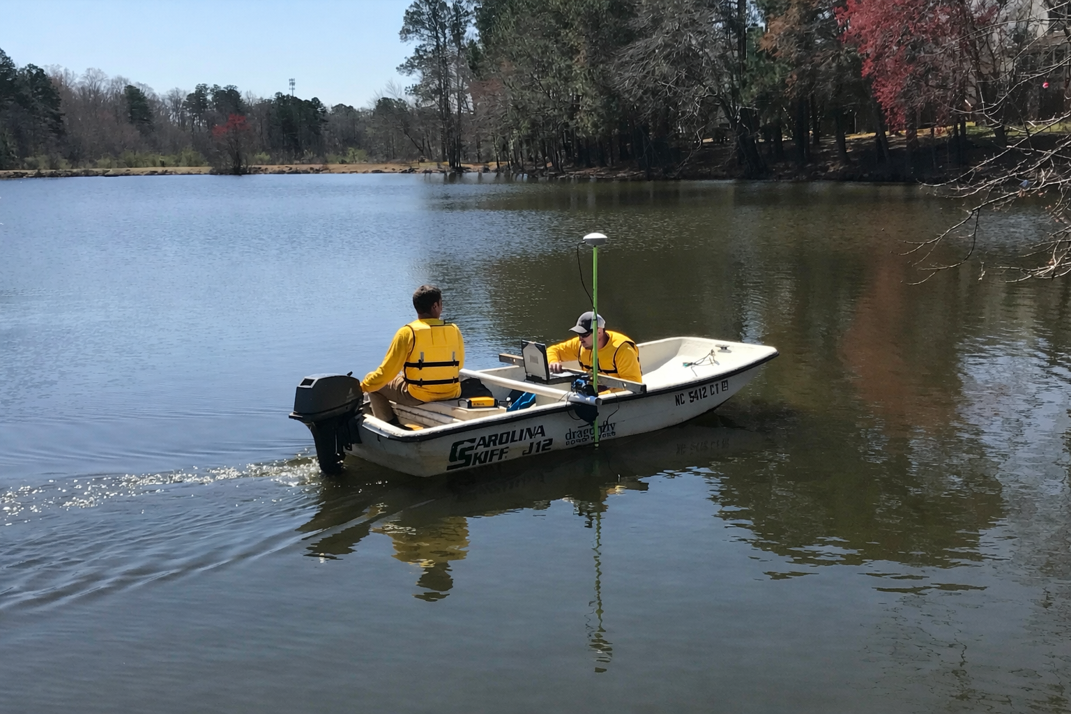
A Stormwater, Pond, & Lake Bathymetry & Sediment Study Guide for HOAs, Community Managers, Facility Managers, and Property Owners: This guide explains how bathymetry and sediment studies measure the amount of sediment that has accumulated in ponds, lakes, and stormwater basins. Using sonar mapping, GPS technology, and sediment probing, these studies calculate sediment depth, distribution, and total volume so property managers, facility managers, and HOAs can plan dredging, maintain stormwater capacity, and prevent flooding.
Do You Know What’s Happening Below the Surface of Your Pond?
Your pond or stormwater basin may look calm and fully functional from above. But beneath the surface, sediment is accumulating — slowly, silently, and predictably.
One of the primary jobs of a community pond, stormwater pond, or lake is to capture sediment and nutrients, preventing them from flowing downstream into rivers and streams. The better your pond performs, the more sediment it collects.
So here’s the real question: How do you know when it’s full? Without measurement, you don’t. That’s where bathymetry and quantitative sediment studies come in.
What Is Bathymetry?
Bathymetry is the measurement and mapping of underwater topography.
Think of it as a land survey, but for the bottom of your pond or lake. It shows:
Water depth
Basin contours
Elevation changes
Areas where sediment has accumulated
For HOAs, facility managers, and property owners, bathymetry provides critical insight into whether a pond is still functioning as designed or if it is losing capacity.
What Is a Quantitative Sediment Study?
A quantitative sediment study measures:
How much sediment has accumulated
Where it is located
How much needs to be removed
It turns mud into measurable, manageable data.
Using advanced tools like:
GPS-guided hydroacoustic sonar
Sediment probing
GIS mapping technology
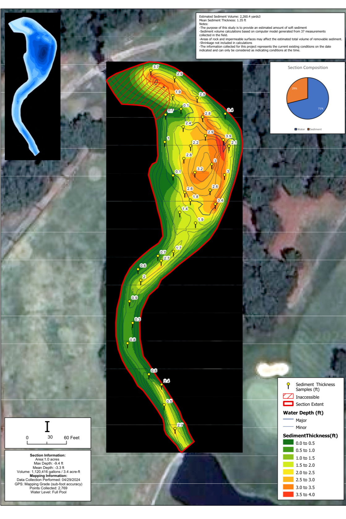
A sediment study provides accurate data on:
Sediment depth and distribution
Total sediment volume (measured in cubic yards)
Water depth
Changes since original basin or lake construction
Sedimentation rates over time
When conducted at regular intervals, typically every five years, sediment studies also allow you to track accumulation trends and plan proactively. This isn’t just a “cool-looking map.” It’s a decision-making tool.
“What is a sediment study? A sediment study measures how much sediment has accumulated in a pond or stormwater basin and calculates how much must be removed. Using bathymetric mapping, sonar, and sediment probing, the study determines sediment depth, distribution, and total volume to help property managers plan dredging and maintain stormwater capacity.”
Why Sediment Studies Matter for HOAs and Property Managers
Sediment accumulation isn’t just an environmental issue. It’s a financial, operational, and liability issue.
1. Avoid Flooding and Property Damage
Stormwater basins, retention ponds, and drainage channels fill slowly over time, until they don’t have the capacity to handle a major rain event.
When capacity is lost:
Water overtops structures
Shorelines erode
Infrastructure becomes compromised
Flooding risk increases
Knowing your sediment accumulation rate allows you to schedule maintenance before failure occurs protecting property, assets, and residents.
2. Maintain Aesthetics and Avoid Community Issues
As sediment builds up, it alters the ecological balance of your pond.
Common issues include:
Algae blooms
Murky water
Foul odors
Reduced aquatic habitat
Mosquito issues
While these may seem cosmetic at first, they quickly become community complaints and board-level concerns. A sediment study provides the data needed to act proactively, keeping your water feature attractive and healthy.
3. Accurate Dredging Estimates (No Guesswork)
A quantitative sediment study provides reliable volume calculations in cubic yards. That means:
Accurate bid packages
Better contractor comparisons
Fewer surprises
Controlled project costs
You design and plan with confidence, not assumptions.
4. Permitting and Regulatory Compliance
Many agencies require verified sediment volumes before issuing:
Dredging permits
Disposal approvals
Environmental impact clearances
Having defensible, data-backed measurements streamlines the approval process and reduces delays.
5. Capital Planning and Budget Justification
HOA boards and facility managers are often asked:
Why now?
How much will it cost?
Can we wait?
A sediment study gives you defensible numbers to support funding requests.
When you can show:
Accumulation trends
Remaining storage capacity
Projected timeline to failure
You shift the conversation from reactive spending to strategic planning.
6. Environmental Restoration and Water Quality Improvement
If your goals include:
Habitat restoration
Stormwater compliance
Improved water clarity
Nutrient reduction
Recreational enhancement
You need to know precisely what to remove and how much. A sediment study defines the scope required to meet those goals efficiently and responsibly.
What You Receive From a Quantitative Sediment Study
At Dragonfly Pond Works, our sediment study deliverables are built for real-world decision-making.
Our reports are:
Engineer-ready for design and dredging teams
Stakeholder-friendly for HOA boards and funding agencies
Permit-compliant for regulators
Visually clear and easy to interpret
Deliverables include:
GIS-based sediment maps
Elevation change diagrams
Sediment volume tables
Water depth contour maps
Capacity analysis
You don’t just receive data, you receive clarity.
How Often Should a Sediment Study Be Conducted?
Most stormwater ponds and lakes should undergo a sediment study every five years.
However, frequency may vary depending on:
Watershed size
Land development activity
Upstream erosion
Local rainfall patterns
Regular measurement allows you to calculate sedimentation rates and predict future dredging needs.
When Is Dredging Necessary?
Dredging is typically required when:
Sediment significantly reduces storage capacity
Flood risk increases
Water quality declines
Regulatory requirements mandate restoration
A sediment study answers the key questions:
How much sediment is there?
Where is it concentrated?
How much will removal cost?
When will we need to act again?
Why Choose Dragonfly Pond Works for Bathymetry and Sediment Studies?
When it comes to protecting your pond, lake, or stormwater system, experience and accuracy matter.
Proven Methods
We combine bathymetry mapping with sediment probing to deliver unmatched measurement accuracy. This dual-method approach ensures dependable volume calculations and defensible data.
Scalable Solutions
Whether you manage:
A commercial retention pond
A multi-pond HOA community
A 200-acre recreational lake
Our approach is customized to your project’s size and complexity. Dragonfly Pond Works is an industry leader in pond and stormwater management. We provide data-driven solutions that protect infrastructure, property values, and environmental health.
Turning Sediment Data Into Smart Planning

Stormwater Pond Management expert operates a low-impact hydraulic dredge on a HOA Community pond to remove accumulated sediment following the completion of a sediment study.
Sediment accumulation is inevitable, but capacity loss is predictable and flooding is preventable.
A quantitative sediment study gives you the hard numbers to:
Plan confidently
Prevent costly property damage
Maintain aesthetics and water quality
Support funding decisions
Execute dredging strategically
If you are responsible for a pond, lake, or stormwater system, the question isn’t whether sediment is accumulating, it’s how much. Get the data you need to make informed decisions. Contact Dragonfly Pond Works to schedule a bathymetric and quantitative sediment study today.
Frequently Asked Questions
What is the difference between bathymetry and a sediment study?
Bathymetry measures underwater depths and contours. A sediment study builds on bathymetry by calculating how much sediment has accumulated and determining removal volumes.
How do you calculate sediment volume?
Sediment volume is calculated using hydroacoustic sonar, GPS mapping, and sediment probing to compare current bottom elevations to original design elevations. The difference is measured in cubic yards.
How often should a pond be surveyed for sediment?
Most ponds and stormwater basins should be surveyed every five years to monitor sediment accumulation rates and plan maintenance proactively.
What happens if sediment is not removed?
Excess sediment reduces storage capacity, increases flood risk, degrades water quality, and may lead to costly emergency dredging or infrastructure damage.
Bathymetry, Sediment Studies, Pond & Lake Dredging, Routine Maintenance, & More
Learn about Dragonfly’s innovative Stormwater, lake, and pond dredging services, available across all of our markets. Discover how proper stormwater pond maintenance keeps your community compliant and your stormwater system working as designed.
Subscribe to our newsletter to receive informative and engaging news delivered right to your inbox.
Find us on Facebook, Twitter, Instagram, and LinkedIn for news, events, and more!
Dragonfly Pond Works provides bathymetry and sediment studies, dredging, specialized pond, lake, and stormwater management, corrective repairs, routine maintenance, and more in Nashville, Davidson County, Murfreesboro, Franklin, and Spring Hill, TN, Charlotte, Raleigh, Durham, Greensboro, and Wilmington, North Carolina, Charleston, Columbia, Myrtle Beach, and Greenville, South Carolina, Tampa, Orlando, Sarasota, Naples, Fort Myers, Florida, Atlanta, Athens, Savannah, Georgia, DC Metro, Fairfax, Northern Virginia, and Rockville, Gaithersburg, and surrounding Maryland, Chicago, Illinois, and Houston, Dallas, Fort Worth, and San Antonio, Texas.