
Lake Mapping & Bathymetric Surveys
Decisions about aeration placement, treatment amounts, dredging, and long-term spending are hard to make without knowing the true shape of the bottom. Our survey team uses sonar and GPS to measure depth, contours, and water volume, replacing estimates with data owners can plan around.
Branch Locations:
Raleigh-Durham, Charlotte, Winston-Salem / Greensboro, Wilmington, Myrtle Beach, Charleston, Greenville-Spartanburg, Atlanta, Savannah, Orlando, Tampa, Virginia Beach, Fairfax, Montgomery County, Lewes, Chicago, Houston, Dallas-Fort Worth, San Marcos Corridor, Nashville
Have a multi-site footprint? Learn how we can work with you
Service DescriptioN
About Our Lake Mapping & Bathymetric Surveys Service
Lake mapping is the process of measuring water depth across a lake or pond and turning those measurements into a clear map of the bottom.
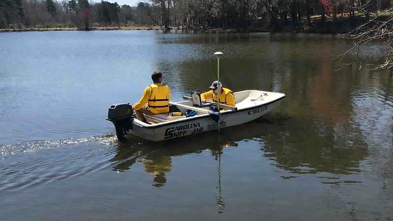
The measurement side is called bathymetry. During a bathymetric survey, our team uses sonar and GPS to record depth across the waterbody. We build a depth map that shows the deep spots, the shallow shelves, and the water volume, drawn as contour lines you can read at a glance.
Dragonfly Pond Works uses lake mapping to plan aeration placement, treatment amounts, plant management, dredging, and other long-term work. It gives owners and managers a factual view of what lies below the surface, which is often the missing piece in a hard decision.
Lake mapping is also the first step when a pond or lake may need dredging. A bathymetric survey shows the depth and contours of the bottom, including the shallow shelves and filled-in areas where sediment has built up. When the question becomes how much material needs to come out, we pair the survey with a sediment study to measure sediment depth and volume. Together, the two give a clear picture of the volume to be removed.
An accurate map supports the health, function, aesthetic appeal, and value of your waterbody over the long term.
Key Benefits of Lake Mapping & Bathymetric Surveys
See What Is Below the Surface
A depth map shows the true shape of the bottom, including drop-offs and shelves you cannot see from shore.
Plan Projects With Confidence
Knowing depth and water volume lets you plan treatments, aeration, dredging, and other work on measured data instead of estimates.
Track Change Over Time
A repeat bathymetric survey shows how the waterbody has changed since the last one, which is useful for long-term planning.
Better Placement of Equipment
Aeration and other equipment work best at the right depth. Lake mapping shows where that is.
Support for Permits and Planning
Engineers, agencies, and boards often ask for depth data. Dredging projects often need it for volume estimates and permit requests.
Protecting Property Value
Good information leads to better decisions for the lake. Residents, visitors, and community members enjoy the result, and so do the homes and common areas around it.
From The Field
Service Photos


How It Works
Plan the Survey
We agree on the area to cover and how the results will be used.
Collect Depth Data
Our crew runs sonar and GPS across the waterbody, recording depth at close intervals.
Build the Map
We process the readings into a clear depth map with contours and water volume figures.
Review With You
We walk through the findings and what they mean for your lake or pond.
Support Next Steps
The map becomes a reference for aeration, treatment, planting, dredging plans, and future surveys.
Why Lake Mapping & Bathymetric Surveys is Important
Depth is one of the most useful facts about a waterbody, and one of the hardest to see. Without it, decisions about aeration, treatment, and planting rest on estimates.
Lake mapping replaces those estimates with data. It shows the contours of the bottom, how much water the lake holds, and how those figures have changed since the last bathymetric survey. That clarity lets owners and managers spend wisely and plan ahead.
Dredging is one example. When sediment has filled in a pond or lake, the survey shows where the bottom has changed, and a sediment study measures how much material has built up and where. That information helps owners decide whether dredging is needed, size the project, compare contractor bids on the same numbers, and plan the budget before work begins. Repeat surveys then show how quickly the bottom is changing.
Lake Mapping & Bathymetric Surveys FAQs
Answers to our most common questions about this service. If you have a different question not answered here, get in touch.
Our crew moves across the lake or pond by boat with sonar and GPS equipment, recording depth at close intervals. We then turn those readings into a depth map.
Accuracy depends on how closely the readings are spaced and the conditions on survey day. We plan the survey around how the map will be used and explain the level of detail before we start.
A depth map supports aeration design, treatment planning, plant management, dredging planning, and budgeting. It is also a useful record for boards and future managers.
Bathymetry is the measurement of water depth. Lake mapping is the finished product, a map that turns those measurements into contours and volume figures you can use. For dredging, a sediment study builds on that map by measuring how much sediment has built up and where, which is what dredging plans depend on.
Many lakes are mapped to set a baseline, then mapped again when major work is planned or conditions change. We can recommend a schedule that fits your goals.
Yes. We offer lake mapping for private homeowner ponds, HOA ponds, community lakes, and waterbodies run by facility managers and municipalities.